The application below to subdivide this open space comes before the Development Committee on the 22nd of this month. It is an attempt- similar to the recent Three Owls Farm application - to continue seeking to develop this space. The image below shows how it looked for many decades until the present owners bought it. Please take the time to support Blakeney Parish Council by endorsing the objections given below and send them to this address.
linda.yarham@north-norfolk.gov.uk

The Appeal Decision follows at the bottom.
1. BLAKENEY - PF/16/0825 - Retention of earth bank; 39 New Road for Mr Lindop &
Ms Jane Armstrong
Each report for decision on this Agenda shows the Officer responsible, the recommendation
of the Head of Planning and in the case of private business the paragraph(s) of Schedule 12A
to the Local Government Act 1972 under which it is considered exempt. None of the reports
have financial, legal or policy implications save where indicated.
Minor Development
- Target Date: 08 August 2016 Case Officer: Mrs G Lipinski Full Planning Permission
CONSTRAINTS
Settlement Boundary
Area of Outstanding Natural Beauty Conservation Area
Open Land Area
RELEVANT PLANNING HISTORY
PLA/19980409 - Erection of two-storey dwelling - Approved
PF/15/0483 - Erection of detached two-storey dwelling - Refused 15/09/2015 Dismissed 03/08/2016)
PF/15/1898 - Erection of two-storey dwelling and detached garage - Refused
THE APPLICATION
Seeks retention of an earth bank
REASONS FOR REFERRAL TO COMMITTEE
Originally at the request of Cllr. A. Wells (prior to resigning as a Councillor) having regard to the earth bank would not enhance the open character of the land and is therefore contrary to the aims of Core Strategy Policy CT1: Open Space Designations. Cllr S. Butikofer has raised no objection to Committee determining the application.
PARISH/TOWN COUNCIL
Blakeney Parish Council: The Parish Council object strongly to the application on the following:
-
It clearly begins to sub-divide the Open Space. The work which has already been
completed is contrary to Core Strategy Policies EN1 (AONB), EN2 (Protection and
Enhancement of Landscape and Settlement Character) and CT1 (Open Space
Designation).
-
This application relates directly to two previously unsuccessful planning applications which
sought to erect detached dwellings at the site (PF/15/0483 & PF/15/1898). Hence this
compartmental use of an Open Land area is significant to the future use of this land.
Development Committee 5 22 September 2016
11/06/1998
(Appeal
14/04/2016
REPRESENTATIONS
Three letters objecting to the scheme have been received. The objections relate to the following:
proposed development would not be detrimental to the character and appearance of Blakeney Conservation Area. Consequently, the Conservation and Design team raised no objection to the proposal.
Landscape Officer:
Three letters objecting to the scheme have been received. The objections relate to the following:
-
Whilst the hedge running along Sheila’s Way would provide a greater degree of privacy to
the applicant, the hedge running east west divides the land into two plots, as per the
recently refused planning applications, and contravenes the open space policy that
applies to the land.
-
The earthworks appear to be a deliberate attempt to envelop the open space and change
its appearance, natural land levels and character in an attempt to overcome the reasons
for the previously refused applications.
-
The works are clearly a device to facilitate the intentions of the applicant to build on the
land and profit therefrom.
-
The earth bank is either a well-meaning proposal or a calculated manipulation of the
planning process; a precursor to develop and an urbanisation of a green space at the heart
of the village.
-
The land has historically been an open meadow which has been enjoyed by generations
and is important to the character and appreciation of the Blakeney Conservation Area.
-
The current application should not be considered in isolation, the two previously refused
applications to erect dwellings at the site have a bearing on this application.
CONSULTATIONS
Conservation and Design Officer:
proposed development would not be detrimental to the character and appearance of Blakeney Conservation Area. Consequently, the Conservation and Design team raised no objection to the proposal.
Landscape Officer:
-
This is a sensitive site located within the Blakeney Conservation Area, Norfolk Coast Area
of Outstanding Natural Beauty and making up part of a defined Open Land Area as
identified in the Local Plan under Policy CT1.
-
The National Planning Policy Framework (NPPF) requires that ‘great weight should be
given to conserving landscape and scenic beauty’ (para. 115). Within this context the
landscape and visual impact of development proposals are key areas of consideration.
-
The earth bank around the perimeter of the site is an acceptable boundary treatment,
formed, as explained within the submission, as a means of improving the soil for the newly
planted hedge.
-
At 350mm in height the bank is in scale with other boundary inclines in the area and will not
appear as a contrived feature in the landscape.
-
The hedge and bank together as a means of defining the site’s curtilage is therefore in
keeping with the site context, which features other mature hedgerows in the vicinity.
 Site visit made on 21 June 2016
by David Troy BSc (Hons) MA MRTPI
an Inspector appointed by the Secretary of State for Communities and Local Government Decision date: 03 August 2016
Appeal Ref: APP/Y2620/W/16/3146342
Land at Little Lane, Blakeney, Holt, Norfolk
-
The appeal is made under section 78 of the Town and Country Planning Act 1990
against a refusal to grant planning permission.
-
The appeal is made by Mr Alistair Lindop and Ms Jane Armstrong against the decision of
North Norfolk District Council.
-
The application Ref PF/15/0483, dated 31 March 2015, was refused by notice dated
15 September 2015.
-
The development proposed is erection of a two storey detached dwelling with garage.
Decision
Main Issue
2. The effect of the development on the character and appearance of the designated Open Land Area and the surrounding area including the Blakeney Conservation Area (the Conservation Area) and the Norfolk Coast Area of Outstanding Natural Beauty (the AONB).
Reasons
-
The appeal site comprises an open parcel of grassed land associated with no.
39 New Road accessed off Little Lane close to its junction with the A149 which
runs through the village. It forms part of a wider area of land designated as
Open Land Area under Policy CT1 of the North Norfolk Core Strategy 2008 (the
Core Strategy) which incorporates an area of open green space, known as The
Pastures, to the north and playing fields associated with the Blakeney Village
Hall to the west. The site is located within the settlement development
boundary, on the western edge of the Conservation Area and within the AONB.
-
The proposed dwelling comprises two elements. The main two storey house
would face northward onto the proposed shingle driveway/parking area. A
single storey L-shaped link extension would be attached at the rear,
incorporating a garage/workshop and utility. The proposed dwelling would be
built using traditional materials with a pitched pantile roof and constructed so
that it would sit into the slope of the site, which rises gradually in an easterly
direction from the A149 road. The proposed boundary treatment includes
enhanced hedge planting and a 1.8m high flint wall on the north western
corner of the site.
Appeal Decision APP/Y2620/W/16/3146342
-
The National Planning Policy Framework (the Framework) postdates the Core
Strategy. However, as is pointed out in paragraph 211 of the Framework, for
the purpose of decision making, the policies should not be considered out of
date simply because they were adopted prior to the publication of the
Framework. Paragraph 215 of the Framework states that due weight should be
given to relevant policies in existing plans according to their degree of
consistency with the Framework. I consider that Policy CT1 of the Core
Strategy is both relevant and consistent in terms of the requirements relating
to the impact on the open character and recreational use of the land. Likewise,
its approach to the circumstance under which development may occur on the
designated Open Land Areas is both relevant and consistent with the
Framework.
-
I note the differing views between the main parties about whether or not the
appeal site would meet the criteria in Paragraph 77 of the Framework and thus,
qualify to be designated as a Local Open Space. However, Paragraph 76 of the
Framework clearly sets out Local Open Space should only be designated when
a plan is being prepared or reviewed and as such is not considered appropriate
to this case. Nevertheless, the land is clearly identified as an Open Land Area
in the Core Strategy Proposals Map and, as such, will be judged against Policy
CT1 which states that “development will not be permitted except where it
enhances the open character or recreational use of the land”.
-
The proposal would represent a significant shift of the built development
northwards into the Open Land Area. The appeal site, together with the
adjoining open space and playing fields, provide a significant contribution to
the visual quality and the openness of the area. It adds substantially to the
character and appearance of this part of the village and provides an important
contribution to the setting of the historic part of the village.
-
Notwithstanding, the above mentioned boundary treatment and proposal to
construct the dwelling into the slope of the site, the proposed development
would not enhance the open character of the land or recreational use of the
land. The site would be visible when approaching the land from both the
north-west and south-east along the A149, from the Pastures to the north and
playing fields to the west. From points within this area the proposed dwelling
would have a significant visual presence. The designation of the site as Open
Land Area recognises the visual quality of the land and importance of the value
of retaining the site as green open space within the village not only in terms of
Policy CT1 but also the Conservation Area and AONB. I conclude that the
proposed development would in principle be contrary to Policy CT1 of the Core
Strategy.
-
Similarly, the scale and design of the building would not relate sympathetically
to the open character of the land and its surroundings. Notwithstanding the
proposed incorporation of traditional materials such as pantiles, red brick and
flint, it would fail to sufficiently reflect the identity of the local surroundings or
reinforce local distinctiveness. The front elevation of the main house and the
proposed balcony running across the northern elevation of the building,
particularly when viewed from the north and north-west, would emphasize the
building’s bulk and its contrast with the built form and the open character of
the appeal site and the surrounding area. I conclude that the proposed
dwelling would have a significant adverse impact on the character and
appearance of the appeal site and the surrounding area.
2
Appeal Decision APP/Y2620/W/16/3146342
-
As such I consider that the proposed development, by virtue of its location,
scale and design would adversely impact on the openness of the Open Land
Area and would be harmful to the character and appearance of the surrounding
area. Consequently, the proposal would conflict with Policies CT1, EN2 and
EN4 of the Core Strategy and paragraphs 58 and 60 of the Framework. These
policies, amongst other things, seek to ensure that development proposals
preserve and, where possible, enhance the special qualities and local
distinctiveness of the settlements and their landscape setting, through high
quality design.
-
The harm would, though, be relatively local in extent and not such as to
materially detract from the overall special qualities of the AONB. However, the
effect of the proposed development on views into and across the Conservation
Area on the approaches along the A149 and from the adjoining open space to
the north and west, respectively, would neither preserve nor enhance the
character and appearance of the Conservation Area or its setting. Whilst the
harm would be less than substantial, it adds to that identified above and that
harm should be weighed against any public benefits to the proposal.
-
I note the appellant’s intention to construct a highly energy efficient building
using traditional materials with additional landscaping and boundary treatment,
which with time, may mitigate, to some extent, the impact of the proposed
building. However, these benefits would not outweigh the harm that the
proposed dwelling would cause to the character and appearance of the
Conservation Area. Consequently, I conclude the development would conflict
with Policies EN2 and EN8 of the Core Strategy and the Framework, which
seeks to ensure that development proposals preserve and, where possible,
enhance the character and appearance of the conservation areas and their
settings through high quality, sensitive design.
-
The proposed dwelling fails to comply with the Framework as outlined above
and also paragraphs 17, 56 and 64, which contain amongst other matters, the
requirement for high quality design that responds to the character and
appearance of the area.
-
I have taken into account all the matters raised in the evidence, including the
comments from those consulted on the application and, those housing
developments and planning permissions in the area drawn to my attention by
the appellant. I am not convinced their circumstances are compellingly similar
to those of the present appeal proposal, particularly given that the detailed
context of the appeal site is important to my assessment. I therefore accord
these limited weight in this case.
-
Both the appellant and the Local Planning Authority have drawn attention to
the previous Inspector’s decision on the site in 1985. However, all planning
appeals must be determined on their individual merits and I have so
determined this appeal.
-
I note the dispute between the main parties about the planning status of the
appeal site as a garden. However, it is not for me, under a Section 78 Appeal
to determine the lawful use of the land. To that end it is open to the appellant
to apply for a determination under section 191/192 of the Act. In any event
Policy CT1 of the Core Strategy applies to the appeal site.
3
Appeal Decision APP/Y2620/W/16/3146342
Conclusion
17. For the reasons given above, and having regard to all other matters raised, I conclude the appeal should be dismissed.David Troy
INSPECTOR
-
The appeal is made under section 78 of the Town and Country Planning Act 1990
against a refusal to grant planning permission.

The Friends of North Norfolk
Protecting the Distinctiveness of this Special Coast
Appeal Decision
Site visit made on 21 June 2016
by David Troy BSc (Hons) MA MRTPI
an Inspector appointed by the Secretary of State for Communities and Local Government Decision date: 03 August 2016
Appeal Ref: APP/Y2620/W/16/3146342
Land at Little Lane, Blakeney, Holt, Norfolk
Main Issue
2. The effect of the development on the character and appearance of the designated Open Land Area and the surrounding area including the Blakeney Conservation Area (the Conservation Area) and the Norfolk Coast Area of Outstanding Natural Beauty (the AONB).
Reasons
Site visit made on 21 June 2016
by David Troy BSc (Hons) MA MRTPI
an Inspector appointed by the Secretary of State for Communities and Local Government Decision date: 03 August 2016
Appeal Ref: APP/Y2620/W/16/3146342
Land at Little Lane, Blakeney, Holt, Norfolk
-
The appeal is made under section 78 of the Town and Country Planning Act 1990
against a refusal to grant planning permission.
-
The appeal is made by Mr Alistair Lindop and Ms Jane Armstrong against the decision of
North Norfolk District Council.
-
The application Ref PF/15/0483, dated 31 March 2015, was refused by notice dated
15 September 2015.
-
The development proposed is erection of a two storey detached dwelling with garage.
Decision
Main Issue
2. The effect of the development on the character and appearance of the designated Open Land Area and the surrounding area including the Blakeney Conservation Area (the Conservation Area) and the Norfolk Coast Area of Outstanding Natural Beauty (the AONB).
Reasons
-
The appeal site comprises an open parcel of grassed land associated with no.
39 New Road accessed off Little Lane close to its junction with the A149 which
runs through the village. It forms part of a wider area of land designated as
Open Land Area under Policy CT1 of the North Norfolk Core Strategy 2008 (the
Core Strategy) which incorporates an area of open green space, known as The
Pastures, to the north and playing fields associated with the Blakeney Village
Hall to the west. The site is located within the settlement development
boundary, on the western edge of the Conservation Area and within the AONB.
-
The proposed dwelling comprises two elements. The main two storey house
would face northward onto the proposed shingle driveway/parking area. A
single storey L-shaped link extension would be attached at the rear,
incorporating a garage/workshop and utility. The proposed dwelling would be
built using traditional materials with a pitched pantile roof and constructed so
that it would sit into the slope of the site, which rises gradually in an easterly
direction from the A149 road. The proposed boundary treatment includes
enhanced hedge planting and a 1.8m high flint wall on the north western
corner of the site.
Appeal Decision APP/Y2620/W/16/3146342
-
The National Planning Policy Framework (the Framework) postdates the Core
Strategy. However, as is pointed out in paragraph 211 of the Framework, for
the purpose of decision making, the policies should not be considered out of
date simply because they were adopted prior to the publication of the
Framework. Paragraph 215 of the Framework states that due weight should be
given to relevant policies in existing plans according to their degree of
consistency with the Framework. I consider that Policy CT1 of the Core
Strategy is both relevant and consistent in terms of the requirements relating
to the impact on the open character and recreational use of the land. Likewise,
its approach to the circumstance under which development may occur on the
designated Open Land Areas is both relevant and consistent with the
Framework.
-
I note the differing views between the main parties about whether or not the
appeal site would meet the criteria in Paragraph 77 of the Framework and thus,
qualify to be designated as a Local Open Space. However, Paragraph 76 of the
Framework clearly sets out Local Open Space should only be designated when
a plan is being prepared or reviewed and as such is not considered appropriate
to this case. Nevertheless, the land is clearly identified as an Open Land Area
in the Core Strategy Proposals Map and, as such, will be judged against Policy
CT1 which states that “development will not be permitted except where it
enhances the open character or recreational use of the land”.
-
The proposal would represent a significant shift of the built development
northwards into the Open Land Area. The appeal site, together with the
adjoining open space and playing fields, provide a significant contribution to
the visual quality and the openness of the area. It adds substantially to the
character and appearance of this part of the village and provides an important
contribution to the setting of the historic part of the village.
-
Notwithstanding, the above mentioned boundary treatment and proposal to
construct the dwelling into the slope of the site, the proposed development
would not enhance the open character of the land or recreational use of the
land. The site would be visible when approaching the land from both the
north-west and south-east along the A149, from the Pastures to the north and
playing fields to the west. From points within this area the proposed dwelling
would have a significant visual presence. The designation of the site as Open
Land Area recognises the visual quality of the land and importance of the value
of retaining the site as green open space within the village not only in terms of
Policy CT1 but also the Conservation Area and AONB. I conclude that the
proposed development would in principle be contrary to Policy CT1 of the Core
Strategy.
-
Similarly, the scale and design of the building would not relate sympathetically
to the open character of the land and its surroundings. Notwithstanding the
proposed incorporation of traditional materials such as pantiles, red brick and
flint, it would fail to sufficiently reflect the identity of the local surroundings or
reinforce local distinctiveness. The front elevation of the main house and the
proposed balcony running across the northern elevation of the building,
particularly when viewed from the north and north-west, would emphasize the
building’s bulk and its contrast with the built form and the open character of
the appeal site and the surrounding area. I conclude that the proposed
dwelling would have a significant adverse impact on the character and
appearance of the appeal site and the surrounding area.
2
Appeal Decision APP/Y2620/W/16/3146342
-
As such I consider that the proposed development, by virtue of its location,
scale and design would adversely impact on the openness of the Open Land
Area and would be harmful to the character and appearance of the surrounding
area. Consequently, the proposal would conflict with Policies CT1, EN2 and
EN4 of the Core Strategy and paragraphs 58 and 60 of the Framework. These
policies, amongst other things, seek to ensure that development proposals
preserve and, where possible, enhance the special qualities and local
distinctiveness of the settlements and their landscape setting, through high
quality design.
-
The harm would, though, be relatively local in extent and not such as to
materially detract from the overall special qualities of the AONB. However, the
effect of the proposed development on views into and across the Conservation
Area on the approaches along the A149 and from the adjoining open space to
the north and west, respectively, would neither preserve nor enhance the
character and appearance of the Conservation Area or its setting. Whilst the
harm would be less than substantial, it adds to that identified above and that
harm should be weighed against any public benefits to the proposal.
-
I note the appellant’s intention to construct a highly energy efficient building
using traditional materials with additional landscaping and boundary treatment,
which with time, may mitigate, to some extent, the impact of the proposed
building. However, these benefits would not outweigh the harm that the
proposed dwelling would cause to the character and appearance of the
Conservation Area. Consequently, I conclude the development would conflict
with Policies EN2 and EN8 of the Core Strategy and the Framework, which
seeks to ensure that development proposals preserve and, where possible,
enhance the character and appearance of the conservation areas and their
settings through high quality, sensitive design.
-
The proposed dwelling fails to comply with the Framework as outlined above
and also paragraphs 17, 56 and 64, which contain amongst other matters, the
requirement for high quality design that responds to the character and
appearance of the area.
-
I have taken into account all the matters raised in the evidence, including the
comments from those consulted on the application and, those housing
developments and planning permissions in the area drawn to my attention by
the appellant. I am not convinced their circumstances are compellingly similar
to those of the present appeal proposal, particularly given that the detailed
context of the appeal site is important to my assessment. I therefore accord
these limited weight in this case.
-
Both the appellant and the Local Planning Authority have drawn attention to
the previous Inspector’s decision on the site in 1985. However, all planning
appeals must be determined on their individual merits and I have so
determined this appeal.
-
I note the dispute between the main parties about the planning status of the
appeal site as a garden. However, it is not for me, under a Section 78 Appeal
to determine the lawful use of the land. To that end it is open to the appellant
to apply for a determination under section 191/192 of the Act. In any event
Policy CT1 of the Core Strategy applies to the appeal site.
3
Appeal Decision APP/Y2620/W/16/3146342
Conclusion
17. For the reasons given above, and having regard to all other matters raised, I conclude the appeal should be dismissed.
17. For the reasons given above, and having regard to all other matters raised, I conclude the appeal should be dismissed.
David Troy
INSPECTOR
INSPECTOR
Three Owls Farm is Back
There are two
applications, the first is for a change in design and the second is for the
same change in design but also, more crucially, for a shift in location to
outside the ‘site area’ and much closer to the first proposal which was
categorically dismissed on appeal. The change in design involves a roof
re-alignment, which doesn’t change the maximum height from the consent given
but increases the amount of roof at that maximum height, thus increasing the
overall bulk and appearance of the building. The building is also larger
by some 4.5% on gross external area (now 828 sq metres cf. the existing bungalow
of 160 sq metres – or 5.18 times larger) with at least one extra room bringing
the total number of ‘rooms’ to 27. The proposed repositioning of the
building in the second application is the most worrying. It has been
moved eastwards a further 17.5 metres away from the existing bungalow (and the
consent given) with at least 60% of the footprint of the building outside the
established ‘site area’ of 0.80 hectares and is now only 10 metres away from
the original application quite clearly dismissed on appeal. The excuse
given is ‘to save the three poplar trees which were to be removed’! In
respect of the Application document relating to both applications: - Item
5. Pre-application advice‘Has assistance or prior advice been sought from the
local authority?’ –This could be useful if it was discovered that was not the
case. Item 14. Biodiversity and Geological Conservation‘Is there a
reasonable likelihood of the following being affected adversely: -(a) Protected
and priority species? – ‘No’. This should be ‘yes’ for land adjacent (and
possibly the development site as they have gone beyond the boundary making the
whole landholding the development site). Nightingales occur on the landholding
and on land adjacent and they are a Schedule 1 species. (b) Designated sites,
important habitats or other biodiversity features? – ‘No’. This again
should be yes relating to Wiveton Downs and land bordering the whole
landholding. Item 22. Site Area What is the site area? – 0.80
hectares – This would not be the case for the second application where the
proposal extends well beyond the site area into the whole landholding of some
15 hectares. On the face of it, it looks as if we may be in for a series
of applications that gradually move this monster house closer and closer
to the applicant’s original application.
With the location of the
house moved there are clear grounds to object once more and we sincerely hope
that all of you will. Recently NNDC have used the Heritage Setting (National
Planning Policy) of Wiveton and Cley Churches in relation to a comparatively
small planning application in Wiveton. In all of the previous Three Owls
applications they disregarded it when it was actually much more significant. So
in the event, however unlikely, that NNDC now consider these Churches worthy of
protection it might be worth including this again.
1. The proposal to move
the house 17 metres to just 10 metres away from that of the original
application, which was quite clearly dismissed at the first appeal.
2. That it has to be
unacceptable to increase the size of a house that will in any case be so hugely
intrusive.
3. It
would be quite reasonable to express concern that through a series of planning
applications and non-material amendments they could eventually circumnavigate
the planning system entirely. That this application should not be dealt with by
delegated authority i.e. decided by officers, that it has go to committee, and
we should petition our local member Andrew Wells to do all that he can to
ensure this happens. Email: Andrew.Wells@ north-norfolk.gov.ukAll
the decisions made by NNDC have (except when forced by an outside inspector to
do otherwise) been refused. Therefore it seems quite reasonable -if only for
consistency - for NNDC to reject them once again
.4. It is
crucial that this is not considered on a comparative basis with what has been
already been approved i.e. it’s only slightly bigger than what has been
approved and only a few metres from the approved position. These are typical
developers tricks to get stuff through. We need NNDC to look at this afresh and
to consider how it sits against the basic policies like H08. Please do take the
trouble to object and very importantly pass this on to all those you think will
respond. To do so follow these links?
http://puretownplanning.co.uk/the-nppf-paragraph-55-formerly-pps7-country-house
This how they do it.
Members of Parliament for English Constituencies
House of Commons
London
SW1A 0AA
Dear Colleague,
Development on brownfield and Green Belt land
This Department has received a large number of identical
letters, forwarded by Members of Parliament, which concern the National Planning Policy
Framework, housing provision, and the need to re-use brownfield land and protect Green Belt.
These concerns arise from our
recent consultation on proposed changes to the Framework,
and from recent misreporting of potential development on Green Belt land. I am writing to
clarify the Government’s position. The claims made in the reports are misleading and
speculative as they include figures based
on unadopted Local Plans and unapproved planning
applications. The Government has put in place the strongest protections for the Green Belt. The
Framework makes it clear that inappropriate development may be allowed only where very
special circumstances exist, and that Green Belt boundaries should be adjusted only in
exceptionalcircumstances, through the Local Plan process and with the support of local people.
We have been repeatedly clear that demand for housing alone will not change Green Belt
boundaries. However, we recognise that it is local authorities, working with their
communities and with detailed local
knowledge, which are best placed to decide the most
sustainable, suitable and viable sites for new homes. The Housing and Planning Act 2016 has
increased local people’s power to plan their areas with new measures to speed up and simplify
neighbourhood planning.
This Government is committed to re-using brownfield sites
for housing, and we have undertaken to ensure that 90 per cent of brownfield land
suitable for housing will have planning permissions for new homes in place by the end of
this Parliament. To support thispolicy, we have introduced local brownfield registers;
accelerated disposal of public sectorbrownfield for housing – with a commitment to release land
for at least 160,000 homes by 2020; extended permitted development to give new life to
thousands of buildings; and set up a Home Building Fund to provide £2 billion of loans for
infrastructure and land remediation to
support large housing sites. We expect 50% of this Fund to
be spent on brownfield land. In addition, £1.2 billion of our £2.3 billion starter homes
funding will support brownfield site preparation; delivering at least 30,000 starter homes.
Green Belt remains constant at around 13% of England, and in
2014-15 there was only a 0.1% reduction in size as a result of Local Plan reviews.
Furthermore, only 0.02% of Green Belt was converted to residential use, after consulting
local people. Taking account of land reclassified as national park, the Green Belt is actually
120 square miles larger than in 1997.
Brandon
Lewis MP Minister of State for Housing and Planning
WHAT IS HAPPENING TO BLAKENEY
Blakeney Quay Before


Which do you prefer?
If like me you are disappointed that BPC have felt it necessary to do this please let them know here.
- by post:
Blakeney Parish Council,
The Parish Office,
Langham Road,
Blakeney,
Nr Holt,
Norfolk
The Parish Office,
Langham Road,
Blakeney,
Nr Holt,
Norfolk
NR25 7PG
- I accept that I may be over-sensitive when it comes to people taking an axe to the village I love and grew up in, and I really do accept that change is inevitable. But things in Blakeney seem to be spiraling out of control. There has been more damage done to the character and fabric of the village in the first few years of this century than in any similar period in its history. Developers are filling every nook and cranny they can find, and the accretion of this piecemeal and unplanned development is becoming seriously detrimental too the look and shape of the village. Blakeney is undisputedly North Norfolk's iconic coastal village, is at the heart of the North Norfolk Coast AONB, and is a Conservation Area; yet greedy developers are pillaging it. It is the responsibility of the Parish Council and NNDC to have an overall plan to ensure that such a special place develops in step with its history. NNDC have the Local Plan (which sadly is now part of the problem here) and Blakeney has a Village Design Statement, which while NNDC claim it no longer accepts as supplementary planning guidance could be used as a basis (supported by its consensus) to oppose the worst of what is happening. Blakeney PC did fight hard to prevent the Three Owls development and have opposed others, but I think they could much more; firstly by setting a good example themselves.
- Which brings me to what is happening around the quayside and the forest of large poles that have destroyed the lovely open views of the marshes, the sea, and of course the quayside itself. Blakeney already had more posts and bollards than most village along this coast, but this is beyond anything anyone could have predicted. Does no one care how the place looks? Diners in the Blakeney Hotel will think they are in prison.
- Having sailed out of Blakeney for over 65 years I do not need a lecture on why these posts are ‘thought’ to be necessary, but it is that long perspective that offers the explanation for why they are not, and never were needed. Apparently BPC approached the Boatman’s Association some time ago asking if they would contribute financially toward these poles. They said NO - because they did not think they were needed. Large boats coming onto the road as occurred in the 2013 surge are rare events, 1953 being the only other time it has happened in living memory; small boats do so more often, but rarely with any significant damage to anything other than themselves. If there were some oversight of quayside moorings this could easily be prevented, or failing that a total ban on boats over ten feet from November to March. Although, having said that boat owners themselves should be responsible for mooring their boats properly along the quay, not the Parish Council. It's no good people just abandoning boats for the winter and expecting others to worry about them – if the owners are too stupid or inexperienced to realise what is needed to prevent them being damaged it is their problem not the Parish Council’s.
- Surely any option would be better than such total desecration of the quayside’s character, particularly as it is completely needless. We do not always need a sledgehammer to crack such small nuts. I may be a lone voice here, and if that’s true I will be silenced by the silence. If not I hope that all of you that feel the same will let BPC know and perhaps they’ll think again? Come on BPC you can do a lot better than this.
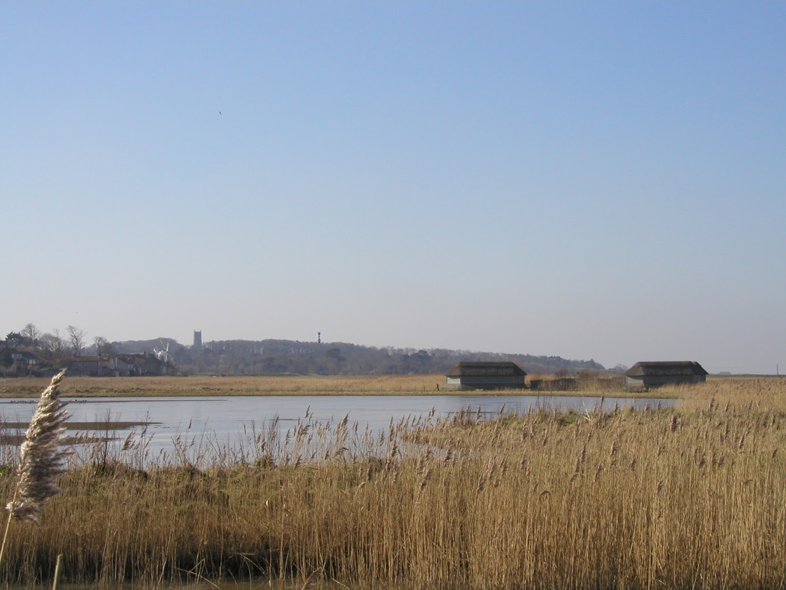
Proposal to erect a 30metre high shared telecommunications tower with six antennas and associated ground-based cabinets. At Friary Farm Blakeney.
Ref: PF/15/1208
I wish to object to the above application on the following grounds
1. The Landscape impact.
Our principal objection to this application is the major landscape impact that a telecommunications mast of this scale would have in this particular location. A prominent headland that constitutes a significant element in the North Norfolk Coast Area of Outstanding Natural Beauty and overlooking two Conservation Areas. It would be hard to understate the importance of this particular landscape feature in the north Norfolk coastal scene, visible in both directions east and west this wooded headland with Blakeney Church at its crest it is as familiar and important a landscape feature in this part of Norfolk as Glastonbury Tor is to its part of Somerset.
A recent study showed that tourism is by quite a large margin the largest underwriter of Norfolk’s economy, of that income a significant amount is generated here in North Norfolk, the reason for this is that the people who visit the area do so because of its unspoilt beauty. Again and again surveys show this to be true.
Visible from the Norfolk Coast Path from as far off as Wells in the west and for a similar distance to the east as far as Sheringham it is also very prominent from a number of important visitor centers. The National Nature Reserve of Blakeney Point, the Harbour and departure point at Morston [See picture 1] where every day during the summer hundreds of tourists stand looking at this view as they wait to embark on excursions to see the seals and bird sanctuary. Cley Nature Reserve to the east also has this belt of trees as its western horizon. [See picture 2] So significant is this site that it is the opinion of all three Parish Councils that this mast represents a defining test of the strength of the AONB designation. If this mast were to go up then the AONB designation comes down, probably to a point where it will not be worth all the mountains policy paper it is written on.
2. The option of St Nicholas Church Tower, Blakeney.
Arqiva claim that the space needed for the required cabinets and their combined weight makes this option untenable. Blakeney Church Tower is one of the largest Parish Church towers in the country and has within it not one [The Belfry] but two [The Clock Room] spaces wherein equipment could be accommodated. Arqiva claim to have examined this option, but from their replies to our enquiries regarding its possible use, it seems fairly clear that they have not done this with any rigor. This option was explored as long ago as 2004 and found to be quite suitable, and it seems odd that Arqiva have not looked at what happened then. We feel it would be a great shame to have these views destroyed when a better option is available. The National Planning Policy Framework states that in an AONB, “ The aim should be to keep the numbers of radio and telecoms masts and the sites to a minimum consistent with the efficient operation of the network. Existing masts, buildings and other structures should be used, unless the need for a new site has been justified. Where new sites are required, equipment should be sympathetically designed and camouflaged where appropriate.”It would seem that Aqiva’s haste to get an application in within the MIP’s limited time frame has resulted in a very superficial assessment of all the other options. This can only produce a result we will regret. Act in haste repent at leisure.
3. The height of the trees:
The line drawing submitted by Arqiva that shows this mast extending just a small amount above the trees is misleading, the trees have been measured and found to be considerably lower than shown of the plan (see drawings included). This difference means that the mast would extend above the trees by 16 metres not the 7.5 metres suggested by Arqiva. The danger here is that focusing attention on the relationship between the trees and the mast tends to suggest that if that relationship can be improved the mast becomes acceptable, and this of course is not true. On this site any structure of any kind that extends above the tree line will be conspicuous in the landscape for a great distance. Perhaps the actual height of the trees can be established by NNDC? A further comment that was made by the inspector at the appeal for the previous application was that these trees are tall, thin and ivy covered, such that their health and stability may not be good, and little weight can be placed on their long term screening value.
4. AONB Policies
The site lies within the north Norfolk Coast AONB and Glaven Valley Conservation Area where North Norfolk Local Development Framework Core Strategy Policies EN1, EN2 and EN8 are relevant.
Policy EN1 states that proposals that have an adverse effect will not be permitted unless it can be demonstrated that they cannot be located on alternative sites that would cause less harm and the benefits of the development clearly outweigh any adverse impacts.
Policy EN2 requires that proposal are informed by the North Norfolk Landscape Character Assessment and that their location, scale and design protect, conserve and where possible enhance the special qualities and local distinctiveness of the area, including visually sensitive skylines, and seascapes.
Policy EN8 requires that development proposals preserve or enhance the character and appearance of designated assets, in this case the Glaven Valley Conservation Area and their setting through high quality sensitive design.
Policies in the current AONB Management Plan.
Policy C9 Supports the provision of necessary facilities and new development to meet proven needs of local communities and businesses, in ways that maintain the area’s natural beauty, including the provision of fast broadband throughout the area”.
Policy PB3 Ensures that new development, including changes to existing buildings and infrastructure, within their ownership or powers of regulation are consistent with the special qualities of the area and relevant conservation objectives”.
Section 3 A Special Place “There are also pressures for other forms ofdevelopment in the countryside and in some cases potential conflict between government and other guidance and AONB protection – for example telecommunications masts and broadband infrastructure – and there may be others, unforeseen at present, in the future. Although development is likely to bring economic benefits, impacts on the areas natural beauty can undermine the natural capital that underpins the tourism industry and makes this an attractive area to live in and visit. We need to manage development so that it is compatible with AONBdesignation.”
5. National Planning Policy Framework Also states thatIn National Parks, the Broads and AONBs, which have the highest status of protection, great weight should be given to conserving landscape and scenic beauty. The aim should be to keep the numbers of radio and telecoms masts and the sites to a minimum consistent with the efficient operation of the network. Existing masts, buildings and other structures should be used, unless the need for a new site has been justified. Where new sites are required, equipment should be sympathetically designed and camouflaged where appropriate.
National Planning Policy Framework – paragraph 45 requires that:- Applications for telecommunications development (including for prior approval under Part 24 of the General Permitted Development Order) should be supported by the necessary evidence to justify the proposed development. For a new mast or base station, evidence that the applicant has explored the possibility of erecting antennas on an existing building, mast or other structure and a statement that self-certifies that, when operational, International Commission guidelines will be met.
[if !supportLists]· [endif]Decisions should be made in line with the Development Plan unless there are valid and overriding reasons for not doing so, based on the merits of the case.[if !supportLists]· [endif]In the absence of up to date Development Plan policies, a decision should be made by consideration of the policies of the NPPF, taken as a whole.[if !supportLists]· [endif]Decisions cannot be made solely on the basis of representations for or against a proposal; they must be based on valid planning grounds, weighing all the evidence and on the merits of the case.
Also.
Conservation Principles, English Heritage, 2008, p72
3) “The setting of a heritage structure, site or area is defined as the immediate and extended environment that is part of, or contributes to, its significance and distinctive character. Beyond the physical and visual aspects, the setting includes interaction with the natural environment; past or present social or spiritual practices, customs, traditional knowledge, use or activities and other forms of intangible cultural heritage aspects that created and form the space as well as the current and dynamic cultural, social and economic context.”
6. Blakeney as a ‘Not Spot’.
In order to qualify for inclusion as part of the Mobile Infrastructure Project, Blakeney needs to be a ‘Not Spot’. In Arqiva’s words "A new base station is needed as part of the MIP to help provide mobile coverage over a 'Not Spot' that affects Blakeney and the wider area".This is not true as a good signal is available from several providers in and around Blakeney and the surrounding area.
Conclusion.
To sum up, I am of the opinion that in their haste to get this mast erected within the tight time scales set by the Mobile Infrastructure Project (and it is not our fault that they are running out of time) the applicant has failed to adequately demonstrate, or fully explore the options of the mast being erected in a less sensitive location or the utilisation of an existing building or structure such as within the tower of St Nicholas Church in Blakeney. As a result the proposal fails to accord with the requirements of the North Norfolk Local Development Framework Core Strategy and NPPF. It is my belief believe that short-term pragmatism in respect of mobile phone signals is not a sufficient excuse for destroying important views within an AONB. The necessary improvements to phone coverage can be achieved without doing that. To that end I would like to request that the NNDC insist that a thorough and impartial examination of Blakeney Church Tower be undertaken before it comes to committee . If that process runs on beyond the present phase of the MIP then so be it; the beauty of this coast and its economy are more important than any difference in cost that may result.


These drawings show first how Harlequin would like us to think this mast will look, and below how it will actually look based on measurements of the trees, which vary from 42 ft - 52 ft in height.The mast will be 98ft 6in
There are always good reasons put forward for doing these things, and most of us would like a better phone signal. BUT it is the beauty of the north Norfolk Landscape that underwrites our economy. At present there are numerous applications in train that represent significant threats to it. The above is just one of them, the value of the landscape should be fought for by all of us. At just a few feet less than the height of Blakeney Church tower (100 ft) this mast will be visible from Morston, Cley and all of Blakeney Harbour, protruding into one of the most famous and best loved views along this coast. There are statutory designations like AONB status, and Conservation Area status that offer protection from such intrusions, and particular protection through the National Planning Policy Framework for the settings of our priceless listed buildings, and we should do all we can to support them. Blakeney Church, the building in question this time, offers a perfect space within its tower ( at the same height as this mast) for this equipment. Last time an initiative to put it there was thwarted because the phone companies wouldn’t work together. They should be made to. Or at least Harlequin should this time.
GLAVEN VALLEY PROTECTION GROUP
But it isn't done yet, despite clear guidelines in the Local Development Framework, there is a notable change of direction by NNDC’s planning officers towards new large, modern buildings in the countryside.
The Glaven Valley Protection Group will meet on September 19th @ 7.00 pm in Wiveton Parish Room to discuss the future role of the group in addressing these concerns. If you would like to be involoved then do please come along.
The Glaven Valley Protection Group will meet on September 19th @ 7.00 pm in Wiveton Parish Room to discuss the future role of the group in addressing these concerns. If you would like to be involoved then do please come along.
The 170 letters of objection NNDC received against this proposal are an indication of how the people who live here feel about this new direction; but will that alter how the planners act? No of course it won’t, because they do not see themselves as answerable to us, they are the professionals and it is we who should accept their advice not the other way round. Several years ago Wiveton spent a good deal of time and money preparing a Village Design Statement which, after a fight was reluctantly accepted by NNDC as supplementary planning guidance. It has sat at the back of the shelf - if not in the waste bin- ever since.
This culture has to change; those who live in a place should have a role in the shaping of it. Until recent times they were entirely responsible for its shape and that is how we came to have the distinctive and much loved architecture of north Norfolk.
Below is an extract from Wiveton Parish Council's three minute contribution at that meeting, as you will see it highlighted the change of direction on the part of NNDC's planning officers. Interestingly one of the councillors also mentioned this.
You have had objections in great numbers, and if you add the almost two and a half thousand people who have visited our web sites to those you’ll get some idea of the level of concern that exists. And from the web site's feedback I can tell you that a storm is brewing along this coast. Despite the Local Development Framework, NNDC planning officers appear to have taken a new direction, one that encourages large new contemporary structures in the countryside, based on an assumption that if their design is radical enough they will somehow enhance it.
No comments:
Post a Comment